Mapping the Distribution and Abundance of Priority Grassland Birds Across Four Joint Ventures in the Southeastern United States.
The Central Hardwoods and Oaks & Prairies Joint Ventures (JVs) have tens of thousands of point-count data documenting grassland bird species’ abundance across both JVs, collected over the last ten years using the same methodology. The data have been pooled and the process of modeling variation in densities of three species (Northern Bobwhite, Eastern Meadowlark and Diskcissel) as they relate to landcover and landscape variables within 250m and 1km radii around the points is underway.
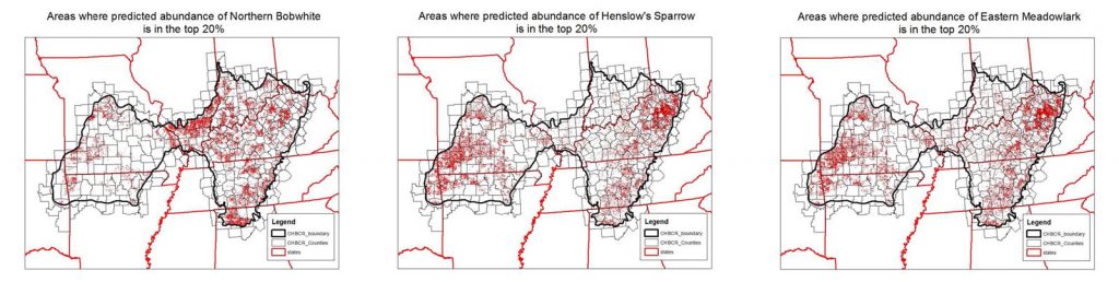
The results of the analyses will be mapped to determine spatially-explicit “hot spots” where the landscape and landcover is most suitable for supporting relatively large and robust populations of the species, and conservation action might therefore be most successful. These maps will be shared with JV partners; JV staff will work with JV board representatives and technical committees to select a subset of the “hotspots” as potential focal areas where it is believed conservation actions can be successfully implemented based on socioeconomic factors; population objectives will then be quantified for each species in each focal area based on potential carrying capacity identified by the modeling process. There are no analysis or maps to date that would lend themselves to that endeavor at such a broad spatial scale, and the JV partnerships are well-positioned to make use of the information to better implement conservation for grassland birds and other wildlife. (A preliminary analysis of the CHJV was completed by the CHJV in recent years; see maps below as an example.)
Given that the other JVs in the southeast, especially the Lower Miss and East Gulf Coastal Plain that neighbor the Central Hardwoods and Oaks and Prairies, don’t have that quantity of point count data available, and that all four are working in concert to fund and implement research to understand how variation in demographic rates is affecting population growth of the meadowlark, bobwhite, and Henslow’s Sparrow across a nine-state region, it would be useful to have good maps of the distribution and abundance of those species across all four JVs, as well. To that end, the mapped outputs from the point count models will be compared to maps of distribution and abundance produced by eBird and the BBS to see if one or both of the latter could provide planning tools of similar quality. The results of the analysis will allow us to generate spatially-explicit population and habitat objectives across the 4 JV-region is a seamless way.
Example of preliminary maps generated for the Central Hardwoods Bird Conservation Region.